 Filter: Categories of Wisconsin Historical Images
Filter: FORMAT_DIMENSIONS of 22 x 28 cm.
Filter: Categories of Wisconsin Historical Images
Filter: FORMAT_DIMENSIONS of 22 x 28 cm.
| Date: | |
|---|---|
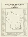
| Description: | A map of Wisconsin showing the gravesite locations of the 43 Revolutionary War soldiers buried in state, surrounding the map are the names and in some inst... |
| Date: | |
|---|---|
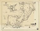
| Description: | A map of the Northern Baptist Assembly estate on the shore of Green Lake, Green Lake County, Wisconsin shows roads, buildings, and private homes. An inset ... |
| Date: | 1974 |
|---|---|
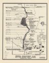
| Description: | This map is a 9 part map detailing various parts of Menominee County, Wisconsin. Page 1 of the map shows federal aid control in the county and was used by ... |

| Date: | 1922 |
|---|---|
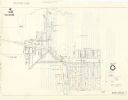
| Description: | A bird's-eye map that shows the Milwaukee Parkway as contemplated by the Milwaukee County Planning Commission. The map identifies the roads and parks throu... |

| Date: | 1913 |
|---|---|
| Description: | This early 20th century map of Saint Croix County, Wisconsin, shows the township and range grid, sections, towns, villages, roads, railroads, and lakes and... |

| Date: | 1916 |
|---|---|
| Description: | Map shows roads, railroads, the Fox River, parks, and cemeteries. Wards are numbered and the edges of the map feature coordinates. The top left of the map ... |

| Date: | 1890 |
|---|---|
| Description: | This map of Superior shows city wards, bays, docks, some businesses and points of interest. Relief is shown by hachures. The back of the map features a typ... |

| Date: | 1928 |
|---|---|
| Description: | This map shows the Forest Hill Cemetery and is oriented with the north to the lower left. The map shows buildings and section numbers but does not include ... |

| Date: | 1938 |
|---|---|
| Description: | This map shows buildings, lots, parks, schools, pumping stations, sites reserved for churches, and water towers. |

| Date: | 1960 |
|---|---|
| Description: | This map includes a sheet index showing streets, proposed streets, the high school, and railroad. |
| Date: | 1960 |
|---|---|
| Description: | This map shows water mains, valves, hydrants, crosses, tees, and elevated tanks. The back of the map reads: "Notice of public hearing from T.H. Schuette, v... |
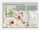
| Date: | 1998 |
|---|---|
| Description: | This map shows the number of Welsh-born heads of households around 1870. A small inset map in the lower left corner shows Welsh land ownership in the heart... |

| Date: | 1966 |
|---|---|
| Description: | This map includes a red overprint on base map and shows the supervisors and district numbers of St. Croix County. Includes diagrams of civil towns, townsh... |
If you didn't find the material you searched for, our Library Reference Staff can help.
Call our reference desk at 608-264-6535 or email us at: